
NOAA’s New Winter Outlook Has Big News For New Yorkers
Planning ahead for winter? NOAA just released its new winter outlook for New York State.
NOAA's Climate Prediction Center released its winter temperature and precipitation outlook map for December 2026 through February 2027.
Seasonal Temperature Outlook
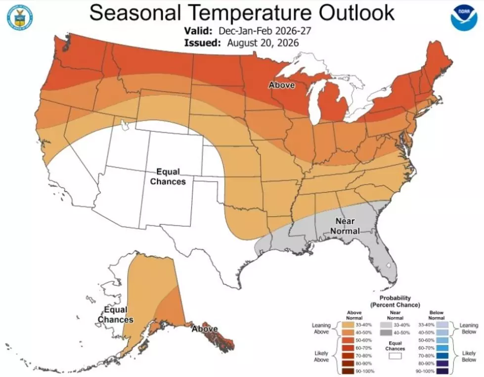
The Climate Prediction Center predicts a warmer-than-average winter driven by a powerful El Niño pattern for most of the country, including the Northeast.
For the Hudson Valley, this means temperatures are favored to run above normal for the bulk of the winter season.
For all the news that the Hudson Valley is sharing, make sure to follow Hudson Valley Post on Facebook, and download the Hudson Valley Post Mobile App
The entire northern United States falls into that above-average temperature category, while areas along the Gulf Coast and parts of the Southeast are looking at near-normal conditions.
No part of the country is predicted to see a colder-than-average winter.
Seasonal Precipitation Outlook

On the precipitation side, most of New York State, including the Hudson Valley and Capital Region, falls into the wetter-than-average zone.

NOAA is favoring above-normal precipitation across much of the South and East Coast. Meanwhile, parts of the northern Rockies and Great Lakes region are expected to see drier-than-average conditions.
It should be noted that this is a three-month probability outlook, not a day-by-day forecast and definitely not a snowfall prediction.
Even if temperatures trend warmer overall, the Hudson Valley can still see stretches of significant cold and winter storms. A warmer-than-average winter doesn't mean a snow-free one.
In fact, experts continue to believe a so-called "Super El Nino" is going to impact New York State this winter.
The NOAA says that New York is one of just four states where residents should be bracing for significant snow and heavy precipitation due to the Super El Nino.
The Super El Nino winter forecast for New York shows heavy precipitation, intense coastal storms, and a razor-thin margin between significant snow and heavy, flooding rain.
